I was noodling around the internet thoroughly investigating the obscure and hidden dark annals of the unknown when I came across the story of Bermeja Island.
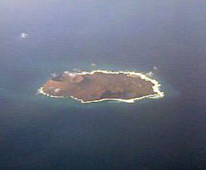
Isla Bermaja as described by Wikipedia
Bermeja is an islet lying off the north coast of the Yucatán Peninsula according to several maps of the Gulf of Mexico from the 16th to the 19th centuries. Despite being located somewhat precisely in relation to neighboring islands by notable Spanish cartographers of the 16th century, the island was not found in a 1997 survey, nor in an extensive 2009 study conducted by the National Autonomous University of Mexico (UNAM) on behalf of the Mexican Chamber of Deputies. Interest in the island arose in late 2008, fueled by the fact that if such an island existed, it would be important for determining the boundaries for exploitation rights of oil in Hoyos de Dona (Doughnut Holes) in the Gulf of Mexico.
Which brings us to perennial favorites among conspiracy theorists, HAARP and DARPA. For the uninitiated, HAARP is the High Frequency Active Auroral Research Program; its purpose is to analyze the ionosphere and investigate the potential for developing ionospheric enhancement technology for radio communications and surveillance. The most prominent instrument at the HAARP Station is the Ionospheric Research Instrument (IRI), a high-power radio frequency transmitter facility operating in the high frequency (HF) band. The IRI is used to temporarily excite a limited area of the Ionosphere. Other instruments, such as a VHF and a UHF radar, a fluxgate magnetometer, a digisonde, and an induction magnetometer, are used to study the physical processes that occur in the excited region. And DARPA, Defense Advanced Research Projects Agency.
While DARPA’s involvement is only as a funding source for HAARP, HAARP is considered by many to be America’s latest attempt to enforce its reign of terror over the rest of the world. Believed by many to be the continuation of the work of Nikola Tesla into the search for “super weapons.” Tesla himself was the target of many conspiracy theories that were possibly based in a smear campaign authored by Thomas Edison since it is Tesla we have to thank for the electricity in our homes and not as most Americans think, Edison. An interesting tale, but not the story at hand.
Tesla’s dream was energy projected out to the world without the use of wires. He took the money he got from Westinghouse, who backed him when Edison would not, and built a research facility in Colorado where he conducted experiments in transmitted energy which some conspiracy theorists have blamed for the Tunguska event in Russia.

Tunguska destruction
Wikipedia
The Tunguska event was an enormously powerful explosion that occurred near (and later struck) the Podkamennaya Tunguska River in what is now Krasnoyarsk Krai, Russia, at about 7:14 a.m. on June 30 1908
Later research determined that to to have been a large meteor or piece of a comet that was near Earth at the time, which exploded above the ground with a force of roughly 15 megatons.
Anywho, this brings us full circle to the Bermeja HAARP conspiracy theory. The location of Bermeja would grant Mexico considerable sovereignty over oil drilling rights in the Gulf of Mexico, as the island has always been recognized as Mexican soil, being part of the Yucatan state. The absence of that island removes those rights and opens drilling to American interests. SO, HAARP being the presumed continuation of Tesla’s “super weapon” research which destructive capabilities were demonstrated halfway around the globe in Tunguska was used by the CIA to destroy the island of Bermeja to open drilling rights in the Gulf to United States interests.
inhale
The fact remains that Bermeja was once placed on the maps with very detailed coordinates associated to nearby islands, today it is not there and no sign of where it might be or where it went. Ocean depths at the location of Bermeja are approximately 40 meters, and so not likely that rising ocean levels could be at fault, as the official explanation claims. You can even go to Google Earth, Flash Earth, or your virtual Earth of choice and a marker will appear in the Gulf for the island, yet no amount of zoom will find you a spot of land.
Drat that Ben, he pulled the lever again.
To plan your Bermeja Island getaway contact
6 comments